If you’re planning a trip to New Zealand and can only do one hike, make it the Tongariro Alpine Crossing. Widely regarded as one of the greatest one-day walks in the world, this iconic trek takes you across an otherworldly volcanic landscape that will leave you speechless. In this complete guide, we cover everything you need to know before you lace up your boots.
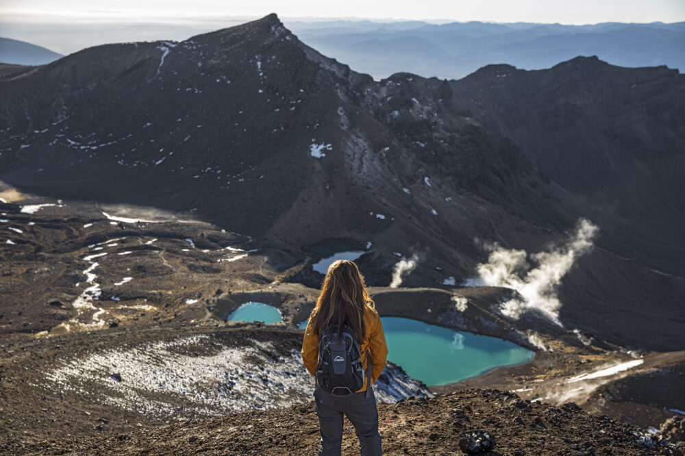
Table of Contents
- What is the Tongariro Alpine Crossing?
- Tongariro National Park
- Tongariro Alpine Crossing: The Day Hike
- Distance & Elevation
- Difficulty Level
- Best Time to Hike the Tongariro Alpine Crossing
- Summer (December – February)
- Spring (September – November)
- Autumn / Fall (March – May)
- Winter (June – August)
- Tongariro Alpine Crossing Weather
- Mount Doom (Mount Ngauruhoe)
- Blue Lake via the Tongariro Alpine Crossing
- What to Wear & What to Bring
- Can You Walk the Tongariro Crossing in Trail Running Shoes?
- Safety Information
- Tongariro Alpine Crossing Map
- Tongariro Alpine Crossing Car Park
- Shuttle Service
- Shuttle from Taupo
- Shuttle from Auckland
- Shuttle from Rotorua
- Guided Tours
- Tongariro Alpine Crossing Accommodation
- What Are the Best Hikes in New Zealand?
1. What is the Tongariro Alpine Crossing?
The Tongariro Alpine Crossing is a 19.4-kilometer (12-mile) point-to-point trail located in Tongariro National Park on New Zealand’s North Island. It is consistently ranked among the top ten single-day hikes in the world — and for good reason. The trail cuts across an active volcanic plateau, passing steaming vents, ancient lava flows, and dazzling emerald and blue crater lakes, while offering sweeping panoramic views that stretch all the way to the distant peaks of Mount Taranaki and the Central Plateau.
The crossing attracts roughly 100,000 hikers per year, making it New Zealand’s most popular walk. Despite its popularity, the experience never feels ordinary — the sheer drama of the volcanic scenery ensures that every step feels like something out of a fantasy world. And that’s not an accident: much of this landscape was used as the fictional land of Mordor in Peter Jackson’s The Lord of the Rings film trilogy.
2. Tongariro National Park
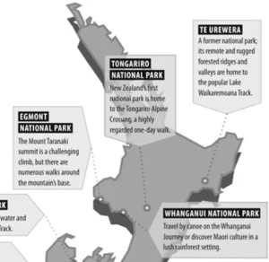 Tongariro National Park is New Zealand’s oldest national park, established in 1887, and a dual UNESCO World Heritage Site — recognized for both its outstanding natural features and its deep cultural significance to the Māori people. The park sits in the center of the North Island and is dominated by three active volcanoes: Mount Ruapehu (2,797 m), Mount Ngauruhoe (2,291 m), and Mount Tongariro (1,978 m).
For the Māori people, these mountains are sacred ancestors, and the gifting of the land to the nation by the Ngāti Tūwharetoa chief Te Heuheu Tūkino IV in 1887 was an act of profound cultural generosity. Today, the park is managed with deep respect for both its ecological values and its spiritual significance to tangata whenua (the people of the land). Visitors are asked to stay on marked tracks at all times and to treat the environment — and its spiritual heritage — with care.
The park is located approximately:
- 330 km south of Auckland (roughly 3.5 hours by car)
- 80 km south of Taupo (just over 1 hour by car)
- 170 km from Rotorua (about 2 hours by car)
The main gateway towns to the park are Whakapapa Village (on the northern slopes of Mount Ruapehu) and National Park Village (a small town just west of the park), both of which offer accommodation, restaurants, and shuttle services.
3. Tongariro Alpine Crossing: The Day Hike
The Tongariro Alpine Crossing is a point-to-point walk, meaning you start at one end and finish at the other — you do not return to your starting point. The traditional direction is from west to east, starting at Mangatepopo Road End and finishing at Ketetahi Road End. This direction ensures you tackle the big climb up to the South Crater in the morning when you’re fresh, then descend through native bush in the afternoon.
Here’s a rough breakdown of what to expect along the route:
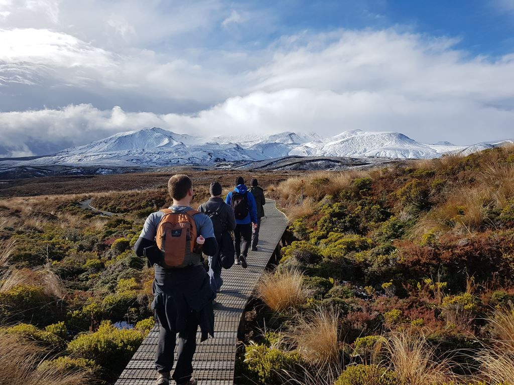
Mangatepopo Valley → South Crater (approx. 4 km): The track begins as a relatively gentle walk across open tussock grassland through the Mangatepopo Valley, following a stream through an ancient lava flow. You’ll pass the junction for the optional Mount Ngauruhoe side trip before the track steepens considerably. The Devil’s Staircase — a steep zigzag climb up a scree slope — is the hardest section of the day and brings you up to the South Crater.
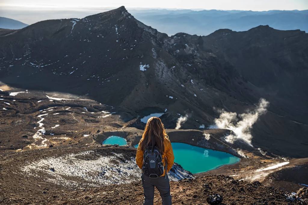
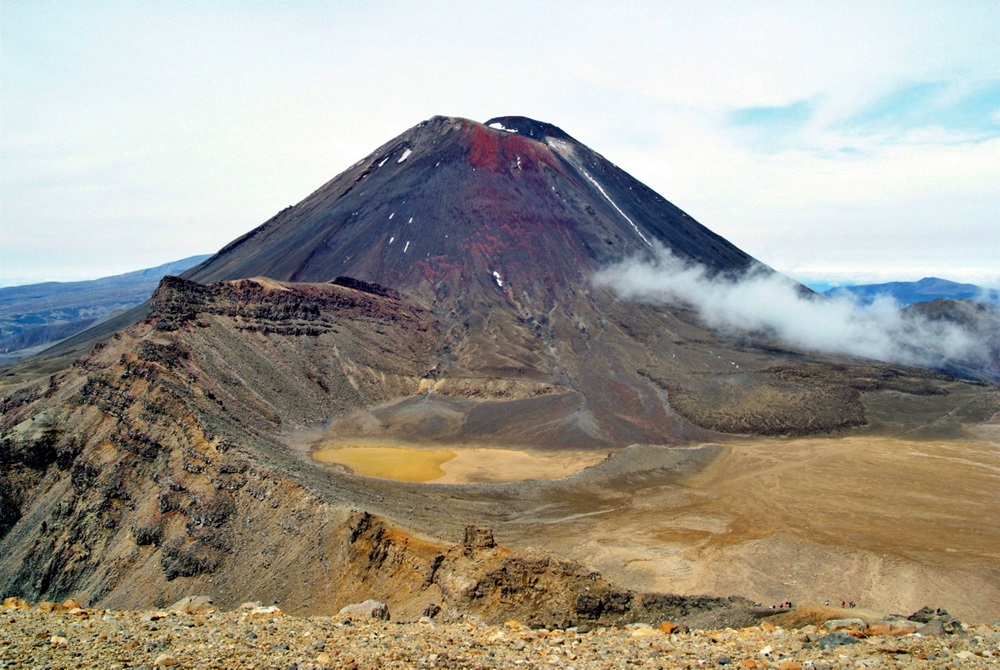
South Crater → Red Crater → Emerald Lakes (approx. 3 km): This central volcanic section is the highlight of the entire crossing. The South Crater is an eerily flat expanse, and the trail climbs again to the Red Crater — the highest point of the crossing at 1,886 m — where steaming vents and vivid rust-red rock make you feel like you’ve landed on Mars. The descent from Red Crater is steep and loose underfoot (watch your footing!), but the reward is immediate: the iconic Emerald Lakes, three turquoise-green crater lakes formed by geothermal minerals, sitting like jewels in the volcanic rock.
Emerald Lakes → Blue Lake → Ketetahi (approx. 12 km): From the Emerald Lakes, the trail continues across the Central Crater to the sacred Blue Lake (Te Wai Whakaata-o-te-Rangihīroa), before winding down through the Ketetahi thermal area and into dense native bush. The final descent through the bush is long but shaded and beautiful, dropping you out at the Ketetahi Road End where your shuttle will be waiting.
4. Distance & Elevation
| Stat | Details |
|---|---|
| Total Distance | 19.4 km (12 miles) |
| Total Ascent | ~1,143 m (3,750 ft) |
| Total Descent | ~1,173 m (3,850 ft) |
| Highest Point | 1,886 m (Red Crater) |
| Start Elevation | ~1,120 m (Mangatepopo) |
| Finish Elevation | ~760 m (Ketetahi) |
| Average Time | 6–8 hours |
The Tongariro Alpine Crossing’s 19.4 km distance may sound manageable. Still, the significant elevation gain and loss — combined with volcanic terrain, possible altitude effects, and unpredictable weather — make this hike demand genuine physical preparation. Budget at least 6 hours if you’re a fit, experienced hiker, and up to 8–9 hours if you’re taking your time, stopping frequently for photos, or making the optional ascent of Mount Ngauruhoe.
5. Difficulty Level
The Tongariro Alpine Crossing is classified as intermediate to advanced in difficulty. It is not a casual stroll, and first-time visitors sometimes underestimate what’s involved. Here’s what makes it challenging:
The ascent of the Devil’s Staircase requires a solid level of cardiovascular fitness. The descent from Red Crater to the Emerald Lakes is steep, loose, and can be genuinely hazardous in wet, icy, or windy conditions. The exposed alpine section — from the South Crater to the Ketetahi shelter — offers very little protection from wind and cold. And the sheer length of the track means tired legs are a real factor in the final few kilometers of descent.
That said, the crossing is achievable for most reasonably fit adults who prepare properly. If you can comfortably walk for 6–8 hours with a day pack, you’ll be fine in good weather conditions. Children under 10 are generally not recommended for this hike. Anyone with knee or joint issues should take special care on the steep descents.
Our difficulty rating: 7/10 — Challenging but achievable for most healthy adults.
6. Best Time to Hike the Tongariro Alpine Crossing
Timing your hike is arguably the most important decision you’ll make. The Tongariro Alpine Crossing sits in an exposed alpine environment where conditions can change rapidly — even in summer. Here’s what to expect in each season.
☀️ Summer (December – February) — Best Season
Summer is peak season on the Tongariro Alpine Crossing, and for good reason. Temperatures are mild, snowfall is rare at trail level, and daylight hours are long — the New Zealand summer sun doesn’t set until well after 8 pm. Expect daytime temperatures of 15–20°C (59–68°F) in the alpine zone, though wind chill can make it feel much colder at the high points. Trails are fully open, facilities are staffed, and the Emerald Lakes are at their most vivid.
The downside? Summer is busy. On popular weekends, the track can have hundreds of hikers on it simultaneously. If crowds bother you, aim for a weekday and set off early (before 7 am).
🌸 Spring (September – November) — Great, With Caveats
Spring is a beautiful time to visit, with wildflowers beginning to bloom and fewer crowds than in summer. However, snow and ice can linger on the upper sections — particularly around Red Crater — well into October or even November. Always check the DOC (Department of Conservation) conditions report before setting out. You may need crampons and an ice axe in early spring, making the crossing dangerous for inexperienced hikers without proper gear.
🍂 Autumn / Fall (March – May) — A Hidden Gem
Autumn is arguably the most underrated time to hike the Tongariro Alpine Crossing. The summer crowds have thinned, the air is crisp and clear, the golden tussock grasses glow in the autumn light, and conditions are often stable and sunny. Temperatures begin to drop in May, and early snowfall is possible in late May, but March and April offer some genuinely superb hiking days. Sunsets are also spectacular in autumn — though given you’ll be finishing well before dusk, that’s more of a bonus for the drive home.
❄️ Winter (June – August) — Experts Only
The Tongariro Alpine Crossing is a fundamentally different — and significantly more dangerous — proposition in winter. Snow and ice cover the upper sections, the Devil’s Staircase becomes treacherous without crampons, and whiteout conditions can develop with almost no warning. Temperatures can plummet below -10°C (14°F) with wind chill factored in. The DOC regularly closes the upper crossing in winter when conditions are unsafe.
Winter hiking here is strictly for experienced alpine hikers equipped with crampons, ice axes, navigation skills, and a thorough understanding of mountain weather. If that’s not you, plan your visit between November and April.
7. Tongariro Alpine Crossing Weather
The weather on the Tongariro Alpine Crossing is notoriously unpredictable. The crossing sits in an exposed alpine environment where four seasons in one day is not just a cliché — it’s a genuine possibility. Clear skies in the morning can give way to fierce winds, heavy rain, or even snow by midday.
A few weather principles to always keep in mind:
Always check the forecast before you go. The Department of Conservation (DOC) publishes a dedicated weather forecast for the Tongariro Alpine Crossing at doc.govt.nz. MetService (metservice.com) also provides detailed alpine forecasts for the region.
Wind is your biggest enemy. The crossing’s exposed ridgeline near Red Crater can channel extreme gusts. When wind speeds exceed 60 km/h (37 mph), it becomes dangerous simply to stand upright. If forecast winds are above 50 km/h, seriously consider rescheduling.
Temperature drops rapidly with elevation. Even on a warm day at the Mangatepopo car park, temperatures near Red Crater can be 10°C (18°F) colder — and that’s before wind chill.
The DOC cancellation threshold. If weather is forecast to be dangerous, DOC will advise against completing the crossing. Shuttle companies and guided tour operators will often cancel trips on these days. Listen to their advice — it can save your life.
General weather statistics for the region:
| Season | Average High (Alpine) | Precipitation | Snow Risk |
|---|---|---|---|
| Summer (Dec–Feb) | 15–20°C / 59–68°F | Moderate | Very Low |
| Autumn (Mar–May) | 8–15°C / 46–59°F | Moderate | Low–Medium |
| Winter (Jun–Aug) | -5 to 5°C / 23–41°F | High | Very High |
| Spring (Sep–Nov) | 5–15°C / 41–59°F | Moderate | Medium |
8. Mount Doom (Mount Ngauruhoe)
No guide to the Tongariro Alpine Crossing would be complete without a full dedication to the mountain that steals the show: Mount Ngauruhoe, better known to Lord of the Rings fans worldwide as Mount Doom.
The perfectly conical silhouette of Mount Ngauruhoe (pronounced “Nau-roo-hoe-ee”) dominates the middle section of the crossing and is arguably the single most striking visual of the entire hike. Rising 2,291 meters (7,516 feet) above sea level, this is one of New Zealand’s most active volcanoes — it last erupted in 1975 and remains an active volcanic vent today.
Peter Jackson used Mount Ngauruhoe extensively as the visual stand-in for Mount Doom in both The Fellowship of the Ring and The Return of the King, filming sweeping aerial shots of the mountain’s near-perfect volcanic cone. For fans of the films, simply seeing it in person — especially with steam vents on the main crater occasionally puffing in the background — is a surreal and deeply cinematic moment.
Can you climb Mount Ngauruhoe? Technically, yes — there is a recognized scramble route from the South Crater Junction that adds roughly 2–3 hours and 500 m of additional elevation to your day. However, the mountain is considered sacred (tapu) to the Ngāti Tūwharetoa iwi, and the Department of Conservation strongly encourages visitors to respect this cultural significance and refrain from climbing it. Many visitors choose to admire the mountain from the track rather than ascend it — a choice that is both culturally respectful and increasingly the preferred approach.
9. Blue Lake via the Tongariro Alpine Crossing
The Blue Lake (Te Wai Whakaata-o-te-Rangihīroa) is one of the most sacred sites on the entire crossing and deserves special mention. Sitting in the Central Crater between the Emerald Lakes and the Ketetahi descent, the Blue Lake is a strikingly beautiful, deep-blue crater lake — and it holds profound spiritual significance to Māori as a place of ritual cleansing.
The DOC asks all visitors to stay on the marked trail around the Blue Lake and not to touch the water — swimming, bathing, and even drinking from the lake are strictly prohibited out of respect for its cultural and spiritual significance. Treat this site with the same reverence you would give any sacred site, and photograph it from the designated viewpoints only.
From a purely visual standpoint, the contrast between the electric blue of Te Wai Whakaata-o-te-Rangihīroa and the deep ochre of the surrounding volcanic rock is extraordinary — especially in good light.
10. What to Wear & What to Bring
Packing correctly for the Tongariro Alpine Crossing is non-negotiable. Many hikers underestimate the alpine conditions and get into serious trouble as a result. Here’s what you need:
🧥 Clothing (Dress in Layers)
- Moisture-wicking base layer (no cotton — cotton is dangerous in cold, wet conditions)
- Insulating mid-layer (fleece or lightweight down jacket)
- Waterproof and windproof outer shell (essential — not just a rain poncho)
- Thermal leggings or hiking pants (avoid jeans at all costs)
- Warm hat and gloves (even in summer — temperatures at Red Crater can be brutal)
- Sun hat and sunglasses (UV exposure is intense at altitude in the Southern Hemisphere)
🎒 Equipment
- Sturdy, waterproof hiking boots with ankle support (see the footwear section below)
- Hiking poles (highly recommended for the steep ascents and descents)
- Daypack (20–30 liters is ideal)
- Sunscreen (SPF 50+ — the New Zealand sun is fierce)
- Headlamp (in case you finish after dark)
- First aid kit
- Emergency whistle
- Fully charged mobile phone (note: coverage is limited in the alpine zone)
🍎 Food & Water
- At least 2 liters of water per person (there are no reliable water sources on the upper crossing)
- High-energy snacks: trail mix, energy bars, sandwiches, fruit
- A proper lunch — this is a long day, and you’ll need fuel
- A hot drink in a thermos for the Red Crater viewpoint (you’ll thank yourself)
♻️ Leave No Trace
- Pack out all your rubbish — there are no bins on the track
- Do not pick wildflowers or disturb wildlife
- Stay on the marked trail at all times
11. Can You Walk the Tongariro Crossing in Trail Running Shoes?
This is one of the most common questions from first-time visitors — and the answer is nuanced. Technically, yes. Practically, it depends.
In ideal summer conditions — dry, warm, no ice — experienced trail runners complete the crossing in minimalist shoes regularly. The track is well-formed for most of its length, and lightweight footwear can be a pleasure on the gentle valley sections.
However, there are significant risks to consider. The loose scree descent from Red Crater to the Emerald Lakes is genuinely technical — slippery, steep, and unforgiving. Without the ankle support of a hiking boot, a twisted ankle on this section is a real possibility. Trail shoes also offer less waterproofing, which becomes critical if conditions turn wet. And in any weather other than pure summer sunshine, the lack of insulation in trail runners can lead to dangerously cold feet at altitude.
Our recommendation: If you’re an experienced trail runner with strong ankles and you’re hiking in confirmed good summer conditions, trail runners are fine. For everyone else — especially first-timers, those with any ankle history, or anyone hiking in shoulder-season conditions — waterproof hiking boots with ankle support are the safer and smarter choice.
12. Safety Information
The Tongariro Alpine Crossing is beautiful, but it commands respect. People have died on this trail — primarily from hypothermia caused by underestimating the weather, and from falls on the steep sections in poor conditions.
Before You Go
- Check the DOC weather forecast specifically for the Tongariro Alpine Crossing
- Tell someone where you’re going and when you expect to return
- Register your intentions at the trailhead or via the Adventuresmart NZ website (adventuresmart.nz)
- If conditions are forecast to be dangerous, postpone your hike — the mountain will still be there tomorrow
On the Track
- Turn back if conditions deteriorate unexpectedly — there is no shame in turning around
- Stay on the marked trail at all times, especially in low visibility
- Help other hikers in difficulty — the hiking community looks after its own
- In an emergency, call 111 and ask for Police/Search and Rescue
Emergency Shelter: The Ketetahi Hut shelter (no longer available for overnight stays) provides emergency shelter only. Do not rely on it as part of your planned route.
Altitude: While 1,886 m is not extreme by international standards, some individuals experience mild altitude effects — dizziness, shortness of breath, and headaches. Pace yourself on the ascent and stay well hydrated.
13. Tongariro Alpine Crossing Map
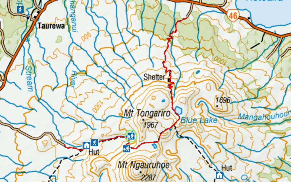
The Tongariro Alpine Crossing follows a clear, well-signposted route from Mangatepopo Road End to Ketetahi Road End. For navigation purposes, the NZTopo50 map sheet BH35 covers the crossing in detail and can be downloaded for free from the LINZ Data Service website.
The DOC also provides a free printed map at the Whakapapa Visitor Centre. For digital navigation, the Topo Maps NZ app is excellent and works offline, making it ideal for areas where cell coverage is unreliable. https://www.doc.govt.nz/map/
Key waypoints on the crossing (west to east):
- Mangatepopo Road End (start, 1,120 m)
- Mangatepopo Hut (1,190 m)
- Mount Ngauruhoe Junction (1,400 m)
- South Crater (1,650 m)
- Red Crater Summit (1,886 m — highest point)
- Emerald Lakes (1,726 m)
- Central Crater (1,700 m)
- Blue Lake / Te Wai Whakaata-o-te-Rangihīroa (1,736 m)
- Ketetahi Shelter (1,470 m)
- Ketetahi Road End/finish (760 m)
14. Tongariro Alpine Crossing Car Park
There are car parks at both ends of the Tongariro Alpine Crossing, but it’s important to understand how they work before planning your logistics.
Mangatepopo Road End Car Park (Start): This car park has limited spaces and is located approximately 10 km from State Highway 47. It is the traditional starting point of the crossing.
Ketetahi Road End Car Park (Finish): Located approximately 12 km from SH 47, this car park is where shuttle services drop hikers off if doing the crossing in reverse, and where shuttles collect hikers at the end of the day.
Important: Because the Tongariro Alpine Crossing is a point-to-point trail, you cannot park at one end and walk back to your car. The vast majority of hikers therefore use a shuttle service to be dropped at the start and collected at the finish — or vice versa. Parking at either end without a shuttle is not recommended, given the trail’s extreme popularity and limited spaces.
In recent seasons, the DOC has experimented with restricting private vehicle access to the car parks during peak periods to manage overcrowding and reduce environmental impact. Always check the current DOC guidelines before planning a self-drive approach.
15. Shuttle Service
Because the Tongariro Alpine Crossing is a point-to-point trail, a shuttle service is the most popular and practical transport option for the vast majority of hikers. Shuttles typically drop you at Mangatepopo Road End in the morning and collect you from Ketetahi Road End in the afternoon. Booking in advance — especially in peak season — is strongly recommended.
Tongariro Alpine Crossing Shuttle from Taupo
Taupo, located about 80 km north of the park, is the most popular base for hikers doing the Tongariro Alpine Crossing. Multiple shuttle operators run daily services from Taupo during the main hiking season (roughly October through April). Departure times are typically between 5:30 and 7:30 am, with afternoon pick-ups between 2:00 and 5:30 pm, depending on conditions. Journey time from Taupo to the trailhead is approximately 1 to 1.5 hours.
Well-regarded Taupo shuttle operators include Tongariro Expeditions, Plateau Outdoor Adventure Guides, and several smaller operators who advertise through local accommodation providers. Prices typically range from NZD $40–$60 per person return.
Tongariro Alpine Crossing Shuttle from Auckland
Auckland is approximately 330 km (3.5 hours by road) from the crossing, making it a very long day trip if you’re planning to drive, hike, and drive back. Some tour operators offer guided day trips from Auckland that include transport, but these involve very early starts — sometimes 3–4 am departures — and very late returns.
A far more sensible approach is to drive down the evening before and stay overnight in National Park Village or Whakapapa Village, then take a local shuttle the following morning. This dramatically improves the quality of your experience and eliminates the exhaustion of a multi-hour drive on top of a demanding hike.
If an Auckland day trip is your only option, search for “Tongariro Alpine Crossing day trip from Auckland” and book well in advance.
Tongariro Alpine Crossing Shuttle from Rotorua
Rotorua sits approximately 170 km north of the crossing (around 2 hours by road). Like Auckland, the distance makes a day trip feasible but tiring. Shuttle and tour operators departing from Rotorua are available and can be booked through local visitor centres and accommodation providers. As with Auckland visitors, an overnight stay in National Park Village or Taupo before your hike is the recommended approach for a more relaxed experience.
16. Guided Tours
The Tongariro Alpine Crossing can be completed independently or as part of a guided tour. For many first-time hikers — particularly those unfamiliar with alpine environments or New Zealand conditions — a guided tour is an excellent option.
A knowledgeable guide brings the volcanic landscape to life, explaining the geology, cultural significance, and natural history of the area in ways a solo hiker simply won’t have access to. Guided groups also benefit from enhanced safety — guides monitor weather conditions closely, carry emergency equipment, and can make real-time decisions about route adjustments or early turn-backs if conditions deteriorate.
Many operators offer small-group guided experiences (8–12 people) that include professional photography, packed lunches, and gear hire — ideal for travelers who want a premium experience without having to organize every detail independently. For those who prefer a hybrid approach, several operators offer a self-guided shuttle + guide hire option where you walk at your own pace but have a guide on hand for key sections of the track.
Popular guided tour operators for the Tongariro Alpine Crossing include Adrift Tongariro, Kaitiaki Adventures, and Tongariro Alpine Crossing Guided Walks. Expect to pay NZD $120–$200+ per person for a quality guided experience, depending on group size and inclusions.
17. Tongariro Alpine Crossing Accommodation
The two main accommodation hubs for the Tongariro Alpine Crossing are National Park Village (to the west) and Whakapapa Village (to the north), with Taupo (80 km north) serving as the major regional base.
Whakapapa Village is the closest settlement to the start of the crossing and offers a small selection of accommodation, including the historic Chateau Tongariro Hotel (a grand, colonial-era lodge worth visiting even if you’re not staying), the Skotel Alpine Resort, and basic DOC campgrounds. Staying at Whakapapa means a very short drive to the trailhead — ideal for an early start.
National Park Village is a small town about 15 km west of the crossing trailhead that caters specifically to hikers and skiers. It offers a good range of budget backpacker hostels, mid-range lodges, and self-catering apartments. The Discovery Lodge, Plateau Lodge, and National Park Backpackers are popular options. A local pub and a handful of cafes keep the small-town atmosphere friendly and relaxed.
Taupo is the nearest major town and offers the widest range of accommodation — from budget hostels and holiday parks to boutique B&Bs and luxury lakeside lodges. If you’re combining the Tongariro Alpine Crossing with other North Island activities (Huka Falls, Lake Taupo kayaking, the Wairakei geothermal area), basing yourself in Taupo for 2–3 nights is a smart choice.
Book accommodation well in advance — the crossing is popular year-round, and the closest properties fill up months ahead during peak summer season (December–February) and school holidays.
18. What Are the Best Hikes in New Zealand?
The Tongariro Alpine Crossing is world-class, but New Zealand is packed with extraordinary walking and hiking experiences. Here are some of the country’s other must-do trails:
The Kepler Track (South Island): The Kepler Track is a spectacular 60-kilometer loop trail in Fiordland National Park, ranked among New Zealand’s nine Great Walks.
The Routeburn Track (South Island): A 32 km multi-day track through Fiordland and Mount Aspiring National Parks, ranked among the great walks of the world. It passes through dramatic alpine scenery, ancient beech forests, and pristine lakes. Allow 2–4 days.
The Milford Track (South Island): Often called “the finest walk in the world,” the Milford Track is a 53.5 km multi-day journey through Fiordland that ends at the iconic Milford Sound. Permits are required, and demand is extremely high — book many months in advance.
The Abel Tasman Coast Track (South Island): A gentler, coastal multi-day walk through the golden-sand bays and emerald waters of Abel Tasman National Park. Combine walking with sea kayaking for the ultimate experience. Allow 3–5 days.
Hooker Valley Track (South Island): One of New Zealand’s most accessible and rewarding short walks, this 10 km return track in Aoraki/Mount Cook National Park leads through glacial moraines and across swing bridges to the Hooker Glacier terminal lake, with dramatic views of New Zealand’s highest peak throughout.
Ben Lomond, Queenstown (South Island): A challenging full-day summit hike above Queenstown with panoramic views over Lake Wakatipu and the Remarkables mountain range.
Cape Farewell Spit Walk (South Island): A unique coastal experience at the top of the South Island, walking the length of the longest natural sandspit in New Zealand.
None of these, however, quite match the pure volcanic drama and cinematic grandeur of the Tongariro Alpine Crossing for a single-day experience. It remains, for good reason, New Zealand’s most iconic one-day walk.
Last updated: February 2026. Always check current conditions and closures with the Department of Conservation (DOC) before your hike at doc.govt.nz.
Quick Reference: Tongariro Alpine Crossing at a Glance
| Category | Details |
|---|---|
| Location | Tongariro National Park, North Island, New Zealand |
| Distance | 19.4 km (12 miles) one way |
| Elevation Gain | ~1,143 m (3,750 ft) |
| Highest Point | 1,886 m (Red Crater) |
| Average Duration | 6–8 hours |
| Difficulty | Intermediate–Advanced |
| Best Season | November – April |
| Start Point | Mangatepopo Road End |
| End Point | Ketetahi Road End |
| Shuttle Required | Yes (point-to-point trail) |
| Shuttle Cost (from Taupo) | ~NZD $40–$60 return |
| Guided Tour Cost | ~NZD $120–$200+ per person |
| Nearest Towns | National Park Village / Whakapapa Village / Taupo |
| Emergency Number | 111 (New Zealand) |
| DOC Info | doc.govt.nz |