Rees-Dart Track: Complete Guide to Mount Aspiring’s Alpine Trail
Rees-Dart Track: Complete Guide to Mount Aspiring’s Alpine Trail
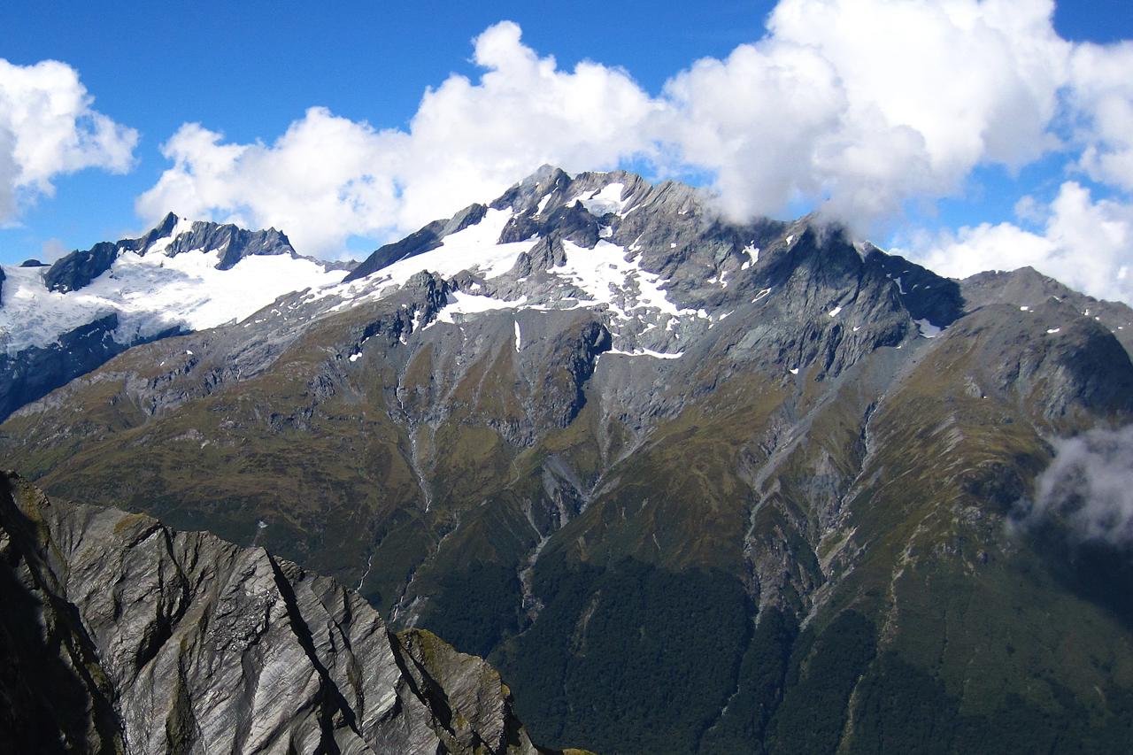
The Rees-Dart Track is one of New Zealand’s great alpine tramping experiences. It sits within Mount Aspiring National Park near Glenorchy. This 63-kilometre route links two spectacular glacier-fed valleys via the high crossing of the Rees Saddle. Trampers cross golden tussock flats, ancient beech forest, and exposed alpine terrain beneath the towering presence of Mt Earnslaw. For experienced hikers seeking a serious South Island adventure away from the busier Great Walks, the Rees-Dart Track delivers scenery that genuinely rivals anything in the country.
Important update: A landslide between Daleys Flat Hut and Chinamans Bluff has closed the Dart Valley section of the track. DOC confirms this closure remains in effect until at least December 2026. Always check the DOC website for current conditions before setting out. Be prepared to walk a partial route, or to use the recommended helicopter transfer around the affected section.
Overview: What Makes the Rees-Dart Track Special
The Rees-Dart Track is classified by DOC as an Advanced Tramping Track, and it earns that rating. Most trampers complete the full route in four to five days. Walking time runs six to eight hours per day. A fifth day is commonly added for a side trip to the Dart Glacier, one of the most rewarding detours on the entire trail.
The route is not a loop. It begins at the Muddy Creek car park in the Rees Valley and ends at the Chinamans Bluff car park in the Dart Valley. The two trailheads sit around 30 kilometres apart by unsealed road. Most trampers walk the route anticlockwise — “up the Rees, down the Dart” — so prevailing winds sit at their back rather than in their face.
Mt Earnslaw, known to Ngāi Tāhu as Pikirakatahi, dominates the skyline throughout much of the walk. Both the mountain and nearby Slip Stream (Te Koroka) are tōpuni, sacred sites of deep significance to Ngāi Tāhu. Trampers are asked to treat the area with appropriate respect.
Day-by-Day Breakdown of the Rees-Dart Track
Muddy Creek to Shelter Rock Hut covers 12 kilometres in four to five hours. The route follows a vehicle track before crossing boggy ground beyond Arthurs Creek. Marker poles guide the way to the national park boundary and on to the hut.
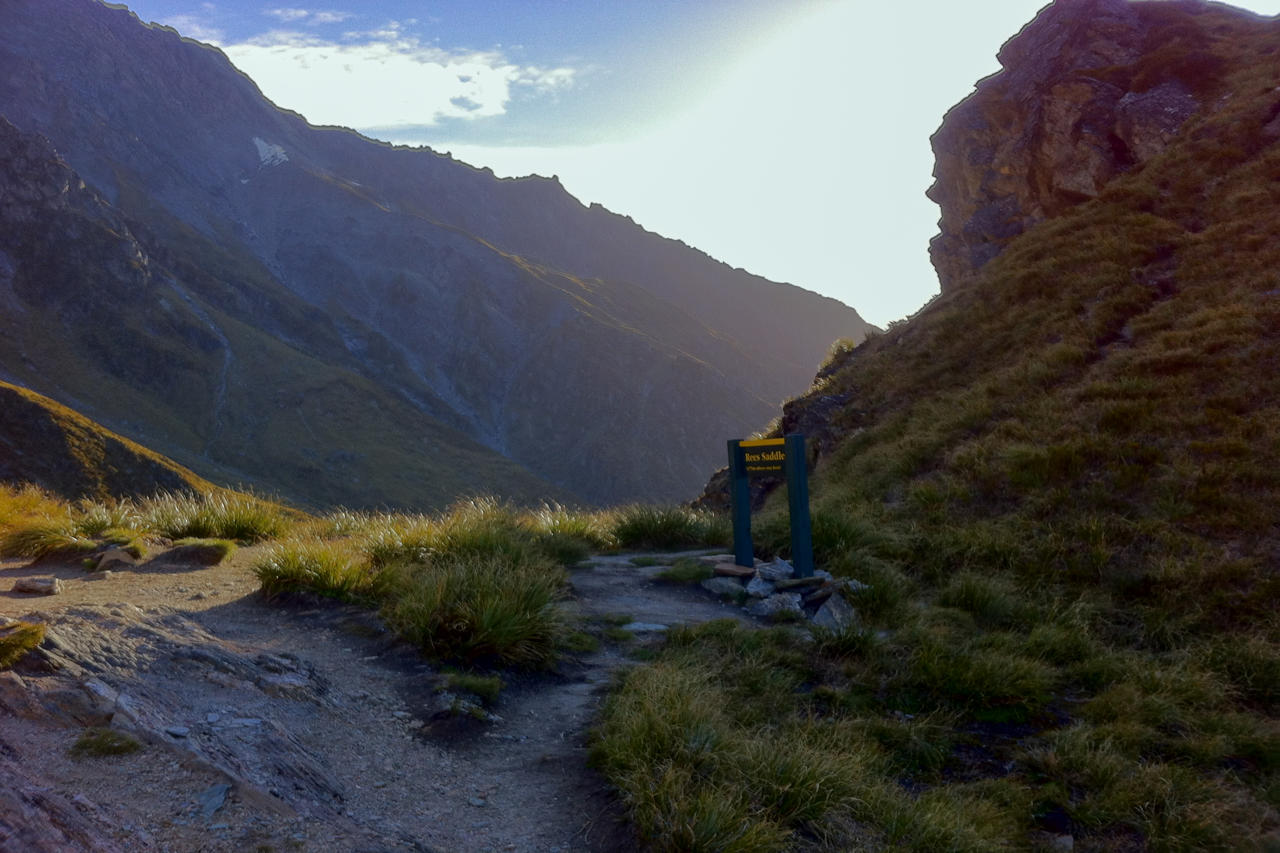
Shelter Rock Hut to Dart Hut is 10 kilometres and takes four to six hours. This is the most demanding section. The track climbs to Rees Saddle at 1,471 metres, the high point of the entire trek. From there it descends past Snowy Creek to Dart Hut. Avalanche paths near the saddle make this stretch genuinely hazardous from late autumn to early summer. The upper Snowy Creek bridge is removed each winter for safety.
Dart Hut to Daleys Flat Hut runs 18 kilometres over five to seven hours, descending through beautiful beech forest to Cattle Flat. This section offers some of the best chances to spot native birds. Yellowheads, kākā, robins, and the cheeky alpine kea are all regularly seen here.
Daleys Flat Hut to Chinamans Bluff is normally a 16-kilometre, five to seven-hour finish through beech forest and along the braided Dart River — but this is currently the closed section described above.
Side Trip: The Dart Glacier
For trampers with an extra day, the side trip from Dart Hut to the Dart Glacier is widely regarded as the highlight of the entire track. The glacial bench above the Dart Glacier is one of the few places camping is permitted outside the formal hut network. It offers a genuinely remote overnight experience. The more demanding Cascade Saddle Route also branches from this area. DOC recommends it only for very experienced trampers with strong navigation skills.
Huts, Bookings, and Practical Logistics
Three DOC huts serve the Rees-Dart Track: Shelter Rock Hut, Dart Hut, and Daleys Flat Hut. All operate on a first-come, first-served basis with no advance booking required. Hut tickets must still be purchased beforehand from the DOC visitor centre in Glenorchy or Queenstown. Huts include solid fuel heating, mattresses, and running water, though trampers need to bring their own cooking equipment.
Camping is permitted along most of the route. It is restricted in the fragile alpine zone between Shelter Rock Hut and Dart Hut, and prohibited entirely on Cascade Saddle. The best walking season runs from late November through April, when avalanche risk is lowest and the Snowy Creek bridge is in place.
Transport to the trailheads requires planning. Info & Track runs scheduled shuttles from Queenstown and Glenorchy during the official summer season. Seats should be booked well ahead. Self-drivers can leave a vehicle at either Muddy Creek or Chinamans Bluff. The 30-kilometre gap between the two car parks via unsealed road is a genuine logistical consideration worth planning around.
Getting to Glenorchy and the Rees-Dart Trailheads
Glenorchy sits at the head of Lake Wakatipu, around 46 kilometres from Queenstown along one of the most scenic drives in New Zealand. The Rees Valley trailhead at Muddy Creek lies a further 68 kilometres from Queenstown, while the Dart Valley trailhead at Chinamans Bluff is 76 kilometres out.
Visitors who prefer not to organise self-drive logistics will find Queenstown a convenient base. Our Queenstown day tours and activities page includes Glenorchy excursions that introduce the valleys without requiring a multi-day commitment. For travellers building a longer South Island itinerary, browse our full range of South Island tours covering Queenstown, Milford Sound, and the wider region.
Preparing for the Rees-Dart Track
The Rees-Dart Track demands genuine backcountry preparation. Pack wet-weather and warm-weather clothing, since alpine conditions can shift quickly even in summer. Carry extra layers too. Clothing worn during the day will likely become wet and unsuitable for evenings at the hut.
Always register your intentions with the DOC office in Glenorchy before setting out, and check out again on completion. This system underpins search-and-rescue response if you fail to return on schedule. Treat all river water before drinking, even at the huts. Expect multiple river crossings throughout the route, particularly in the Dart Valley sections.
More South Island Hiking Inspiration
If the Rees-Dart Track appeals to you, our guide to the best hikes in New Zealand covers other standout multi-day trails across both islands. For broader trip planning, our New Zealand hiking tours page outlines structured itineraries, and our adventure activities in New Zealand page rounds up everything from jet boating to glacier hikes for travellers wanting more than one type of adventure on their trip.
Rees-Dart Track: A Serious Trail for Serious Trampers
The Rees-Dart Track rewards the effort it demands. Few trails anywhere in New Zealand combine glacier-carved valleys, an alpine saddle crossing, and genuine backcountry remoteness so completely. The current Dart Valley closure makes careful planning more important than ever. Even so, the experience on offer remains one of the finest alpine adventures the South Island has to offer.
Ready to plan your South Island adventure? Explore our full range of South Island tours and start building your New Zealand itinerary today.
FAQs
Q: Is the Rees-Dart Track open in 2026?
The Rees Valley section and the upper Dart Valley up to Daleys Flat Hut remain open. However, a landslide between Daleys Flat Hut and Chinamans Bluff has closed that section of the Dart Track until at least December 2026. Always check the DOC website for the latest track status before planning your trip, since alpine track conditions can change quickly.
Q: How difficult is the Rees-Dart Track?
The Rees-Dart Track is classified by DOC as an Advanced Tramping Track, suited to experienced and well-prepared trampers. It involves a high alpine saddle crossing at 1,471 metres, multiple river crossings, and exposed terrain that can be hazardous in poor weather. It is not recommended for first-time multi-day hikers without backcountry experience or proper equipment.
Q: How long does it take to walk the Rees-Dart Track?
Most trampers complete the Rees-Dart Track in four to five days, walking six to eight hours each day between huts. A fifth day is often added to allow a side trip to the Dart Glacier, which many consider the highlight of the entire route. Fit, experienced trampers occasionally complete sections faster, but four days is the realistic minimum.