Roys Peak Track: Complete Hiking Guide, Wanaka, NZ
Roys Peak Track: Complete Hiking Guide to Wanaka’s Iconic Viewpoint
Roys Peak Track is the most photographed hike in New Zealand, and for good reason. This 16-kilometre return trail climbs steeply above Lake Wanaka. It leads to a viewpoint that has become an icon of South Island travel. The switchback path rises through farmland and tussock grassland. At the top, it delivers sweeping views over the lake, the town of Wanaka, and the snow-capped peaks of Mount Aspiring National Park. It is a tough climb, but the reward explains why Roys Peak Track tops so many South Island bucket lists.
Roys Peak Track Overview: Distance, Time, and Difficulty
Roys Peak Track covers 16 kilometres return. Most walkers complete the full out-and-back hike in five to seven hours. The elevation gain is substantial, rising around 1,228 metres from the car park to the official summit. DOC rates Roys Peak Track as strenuous. The climb is relentless rather than technical, with no ropes, ladders, or scrambling sections. The trail is simply a wide, well-formed path that climbs steadily the entire way.
Many hikers stop at the famous Roys Peak viewpoint rather than continuing to the true summit. This viewpoint sits about 6.5 kilometres into the trail. It offers the classic photo overlooking Lake Wanaka. From there, the actual summit lies a further 1.5 kilometres away, around 30 minutes of additional climbing. The summit views are broader, taking in the full mountain panorama. Many hikers still find the famous viewpoint reason enough to turn around there.
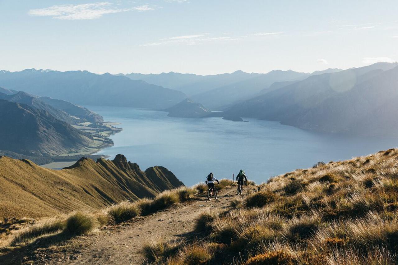
The Famous Roys Peak Viewpoint
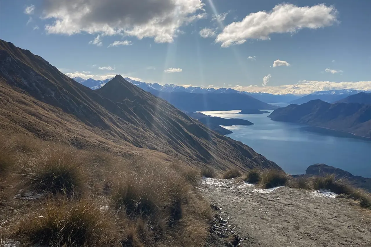
The viewpoint that made Roys Peak Track internationally famous sits on a narrow ridge above Lake Wanaka. On a clear morning, the photo opportunity here is genuinely spectacular. The lake’s islands and inlets sit framed by the Southern Alps below. Because of its popularity, queues can form at the exact photo spot during busy summer mornings. Arriving early, ideally for sunrise, is the best way to enjoy the view without a long wait.
Toilets are available both at the trailhead car park and near the viewpoint. This recent addition has improved the experience for the large number of visitors the trail now attracts each year. The track now ranks among the most-visited day hikes in the country, a remarkable shift from its relatively quiet status just a decade ago.
Best Time to Hike
Roys Peak Track is open year-round, but seasonal conditions vary considerably. The track closes completely from 1 October to 10 November each year for lambing season. The lower sections cross private farmland during this period. It reopens on 11 November, just in time for the peak summer hiking season.
Summer brings the busiest crowds, particularly around sunrise and sunset. Hiking at dawn is popular for good reason. The trail empties out after the morning rush, and golden light at sunrise is widely considered the best time to photograph the famous viewpoint. Winter hiking is possible but demands serious preparation. Snow and ice are common above 1,000 metres. DOC recommends crampons or microspikes in icy conditions. The upper section also crosses avalanche terrain in winter, so check conditions with the Wanaka Visitor Centre before setting out.
Getting to the Roys Peak Track Trailhead
The Roys Peak Track car park sits on Mount Aspiring Road. It is around six kilometres from central Wanaka, roughly an eight-minute drive. There is no public transport directly to the trailhead, though taxis and some accommodation providers offer shuttle services. The car park fills quickly during summer, often by 9 am. Arriving early secures both a parking space and a quieter trail.
During peak season, walking or cycling to the trailhead via the Waterfall Creek Track offers a useful alternative when parking is full. A small donation box collects a $2 track fee at the trailhead. This helps maintain the trail and supports the landowners who allow public access across their farmland.
What to Pack for Roys Peak Track
The exposed nature of Roys Peak Track means preparation matters more than fitness alone. There is no shade along the entire route. Sunscreen, a hat, and plenty of water are essential, even on cooler days. Weather changes quickly at altitude. Temperatures at the summit can be dramatically colder than at the car park. Pack layers, including a warm jacket and a light waterproof shell, regardless of season.
Sturdy walking shoes with good grip help significantly on the steep switchback sections, especially on the descent. Hikers planning a sunrise or sunset start should also carry a head torch. The upper sections can be genuinely dark before dawn or after dusk.
Rules and Restrictions
The lower section of Roys Peak Track crosses active farmland. Dogs are not permitted at any time as a result. Camping is also prohibited along the entire route and at the trailhead car park. Hikers should stay on the formed track at all times. This protects both safety and the goodwill of the private landowners who continue to allow public access across their property.
Alternatives and Nearby Hikes
For hikers seeking a quieter alternative with similarly dramatic views, the nearby Isthmus Peak Track is a popular substitute during the Roys Peak lambing closure. It offers comparable elevation gain and views over both Lake Wanaka and Lake Hawea, with considerably fewer crowds. Many local guides consider Isthmus Peak an underrated rival to Roys Peak Track itself.
For those who want to combine the hike with a wider exploration of the region, our Lake Wanaka day tours and activities page covers the best of the town and surrounding national park. Our Arrowtown and Wanaka Highlights Tour is also a great option for pairing the hike with the historic gold rush charm of nearby Arrowtown.
Combining Roys Peak with a South Island Itinerary
Wanaka is about 1 hour from Queenstown via the scenic Crown Range Road. This makes Roys Peak Track an easy addition to a wider South Island itinerary. Many visitors base themselves in Queenstown and make the drive for a day hike. Others choose to spend a night or two in Wanaka to enjoy the lakeside town at a slower pace.
For travellers planning a longer trip, our South Island tours page outlines itineraries combining Wanaka with Queenstown, Milford Sound, and the West Coast glaciers. The track earns its rightful place among the South Island’s essential hiking experiences, whether on any of these routes.
Roys Peak Track: Worth Every Step of the Climb
Roys Peak Track is steep, exposed, and undeniably crowded at peak times. Yet it remains one of the most rewarding day hikes anywhere in New Zealand. The views over Lake Wanaka and Mount Aspiring National Park live up to the hype that has made this trail a social media icon. Whether you stop at the famous viewpoint or push on to the true summit, the climb delivers one of the South Island’s most memorable panoramas.
Ready to plan your Wanaka adventure? Explore our full range of South Island tours and start building your New Zealand itinerary today.
FREQUENTLY ASKED QUESTIONS
Q: How long does it take to hike Roys Peak Track?
Most hikers complete the full 16-kilometre return Roys Peak Track in five to seven hours, including rest breaks and time at the viewpoint. Fast, fit hikers sometimes complete it in around four hours, while those stopping at the famous viewpoint rather than the true summit can save roughly an hour off the total time.
Q: Is Roys Peak Track open all year?
Roys Peak Track is closed completely from 1 October to 10 November each year for lambing season, as the lower sections cross active farmland. It reopens on 11 November and remains open through the rest of the year, though winter conditions bring snow, ice, and avalanche risk above 1,000 metres that require extra preparation.
Q: Do you need to reach the summit, or is the viewpoint enough?
The famous Roys Peak viewpoint sits around 6.5 kilometres into the track and offers the classic photo overlooking Lake Wanaka, which is why many hikers turn around there. The true summit lies a further 1.5 kilometres and roughly 30 minutes beyond, offering a broader 360-degree mountain panorama for those willing to continue.